| OCR Text |
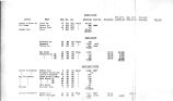
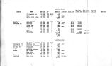
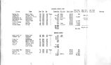
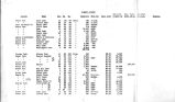
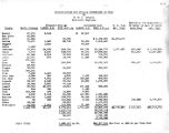
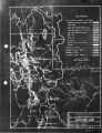
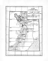
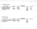
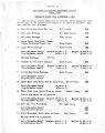
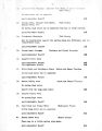
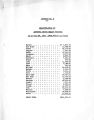
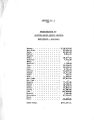
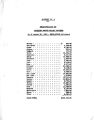
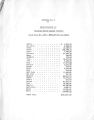
Show UTAH STATE PLANKING BOARD 329 State Capitol Salt Lake City, Utah October Zf 1934 XJtah Stat ® Planning Board Division of Water Resources Salt Lldse City, Utah WATER STORAGE Qentlsmea! ( 1) Attached hereto is a report and map showing existing reservoirs and available reservoir sites in the state of Utah,; The data for this report has been compiled by G, lf « P « Dougali, hydraulic engineer on the staff of the Planning Board, from information available in the B. 8 » G. S,, U. S. R. S., the State Engineer* s office and other sources, ( 2) This compilation is the first step in a comprehensive study of all water resources of the state. The next state wide study will be a record of the gauging stations of the state together with flow measurements as indicated by these stations0 ( 3) On this data and on information takes from the land us © studies we expect to base conclusions of a very general character in regard to possible farther development In agriculture, in power, in recreation, etee ( 4) The information derived from these studies will next bs transferred to regional maps, such as the one we now hove on the way for the Salt Lake- Ogden region. On these larger scale maps we expect to indicate possible developments and have information of sufficient accuracy to determine whether these developments deserve farther field study and detailed engineering investigation0 ( 5) As time becomes available there will be submitted stellar general studies on drainage, flood problems end stream pollution„ For the Salt Lake- Ogden regional plan studies of this type have already been started and will reach compilation before long,, ( 6) 5XISTINS RESERVOIRS.; The attached report shows a total built storage of 1,434,709 acre feet capacity. Of this total storage 73% is found In the large reservoirs located in six counties,, namely: Carbon County 72,478 AF Juab " 270[ 500 " Piute 8 143,101 n Summit * 85,71E n Utah * 201,736 « Wasatch * 282,000 " |