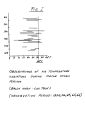
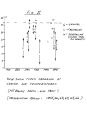
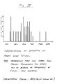
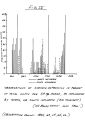
| OCR Text |
Show 1 TERRAIN & ASPECT The Mt. Baldy Recreation Area is located at the north extremity of San Antonio Canyon on the Angeles National Forest. The snowplay area consists of a narrow canyon bottom ( southwest exposure) with steep rising sides ( 50 to 90 degrees), extremely rocky, and sparsely covered with mixed brush and timber. Approximately £ mile to the north, these same canyon walls on the east side are utilized by the Mt. Baldy Ski Area as part of the ski trai1 system. Elevations range from 6500' at the bottom of # 1 ( Sugarpine) lift, up to 8500' at the top of # 3 ( Thunder Mt.) lift. The headwall of San Antonio Canyon, which forms an east to west sj) ddle ( elev. 78OQ1), is also the divide between the Mojav^ desert and ocean drainages. Distance in air mile's from Baldy ( Notch to the valley floors to both north and south is approximately 10 miles. The above mentioned saddle, or divide, at Baldy Notch is bordered by Mt. San Antonio ( elev. 10,080') to the west, and Thunder Mt. ( elev. 85OO1) to the east. Alternate canyons, or faces, emptying from these elevations into San Antonio Canyon, constitute the majority of hazardous slide paths, since they ultimately reach the # 1 lift line, or the snowplay area. WEATHER Either the desert or ocean dominates the Mt. Baldy weather; at times there is a violent clash of the two. A definite weather pattern can be traced. The desert, or north influence, most common in fall or early winter, is often in the form pf. strong gusty " Santa Ana" winds. Gusts up to 90 miles per hour have been recorded at Baldy Notch. This is a warm |